Why there's so much empty land west of the 101 freeway
If you've been to the football stadium in Glendale, Arizona, you've seen a lot of empty land west of the 101 freeway that runs just to the west of it. And when you consider how much the Phoenix metro area has sprawled in the last few decades, you may wonder why this land is still mostly gravel pits, raw desert, and farmland. It has to do with the floodplain of the Agua Fria River.
Now waitaminute, don't get carried away with the word "river". Like all of the rivers, and creeks, etc. on maps in the Phoenix area, the Agua Fria is a riparian wash. That it, it's a place in the desert that water flows through after a rain, and then dries up mostly. It's like Skunk Creek, or New River. These are washes. Unlike the creeks and rivers where I grew up, in Minneapolis, which have water in them all of the time, the rivers and creeks around Phoenix are usually dry. In the summer they're bone dry, and in the winter they can go from carrying water in spots, to just being kinda muddy. If you've ever hiked through washes, you know that.
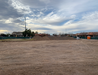
Yesterday, after visiting the Farmer's Market at West Park Mall (99th Avenue and Northern) I wandered over to look at the Agua Fria River. The mall is, essentially, on the eastern banks of New River. As you go west, you're heading for the banks of the Agua Fria River (which is the photo at the top of this post). Of course, like I say, it's not exactly like standing on the banks of the Mississippi River, because there isn't water in there all of the time, but if you look at a satellite view of the area just west of 111 Avenue you can see what is essentially the "high water line", and the subdivisions abruptly stop. The floodplain is so enormous that as you drive through it, it's hard to get a sense of the width of the river, which at that point is at the middle just east of El Mirage Road, and the land rises up again just before you get to Dysart Road.
Controlling the floodplain of the Agua Fria River has not been a priority for the Phoenix metro area. After all, there are a LOT of places to build houses and businesses in, with no need for massive flood control, so I don't expect that the Agua Fria Flood Plain will be a flood control project that I'll see in my lifetime. It really just makes sense to leave it there, and work around it. Certain businesses (and even some homeowners) are OK with being in a flood plain, and if it gets too wet there, they'll just deal with it.
Controlling the floodplain of the Agua Fria River will be a massive project, possibly the biggest that the valley area has ever done. I'm no engineer, but my best guess is that it will be done with gigantic underground storm drains. And once it's done, like all of the other floodplain projects in Phoenix (including the Cave Creek Floodplain, which had been catastrophic for Phoenix for years), it will be forgotten. Neighborhoods will be built there. The landfill will probably be converted into a golf course, like the Cave Creek landfill (now the Cave Creek golf course) was.
Image at the top of this post: Looking west across the Agua Fria River at about 111th Avenue and Northern, Peoria, Arizona. You're looking toward the White Tank Mountains.
If you liked this article, and would like to see more, please consider becoming a patron of History Adventuring on Patreon. If you're already a patron, thank you! You make this happen!
Click here to become a Patron!
History adventuring posts are shared there daily. The basic tier is a dollar a month, and the PhD tier, which includes "then and now" photos, billboards, aerials, videos, and super high-definition photos, is five dollars a month, and is discounted for seniors, veterans, and students.


Comments
Post a Comment